Activity 4
Crop area estimation using remote sensing

Adaptation and application of the methodologies for area estimation developed by European institutions for the two study regions: the HUAIBEI plain in Anhui province of China and the unique cereal production region in Morocco. The target cereal on both study area is wheat. The tasks consist of:

  • sampling the target areas,
  • analysing and compute the crop fractions in the samples,
  • analysing and interpreting the remote sensing data and compute the crop area from the interpretation,
  • establish a regression model using both estimators from sampling and remote sensing data to estimate the single crop area.

Crop area estimation using remote sensing

Crop area estimation using remote sensing


Rapid eye image over Guoyangcounty
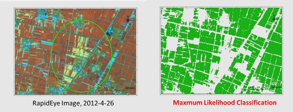
Figure: Rapid eye image over Guoyangcounty registered on April 26, 2012 and its classification results showing the classe of winter wheat